
Monitoring of halophytic habitats
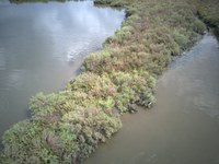
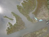
During the ante operam (before interventions) monitoring, Researchers from UNIVE-DAIS are mapping emerged halophytic vegetation (i.e, plants which tollerate salt and temporarily tidal flooding). From April 2018, several sampling campaigns were performed on field, also through an ISPRA drone survey for detailed analysis. Researchers and technicians are now elaborating and digitalizing data to return specific thematic maps.
Monitoring action including these activities is Action D.2, which also focus on the monitoring of halophytic habitats located in the saltmarshes surrounding the freshwater input and reedbed transplantation sites. The aim is to evaluate the variation on halophytic habitats distribution induced by the project interventions. Indeed, Scientists will perform the same activities at the end of the interventions for comparing purpose.
