Online maps

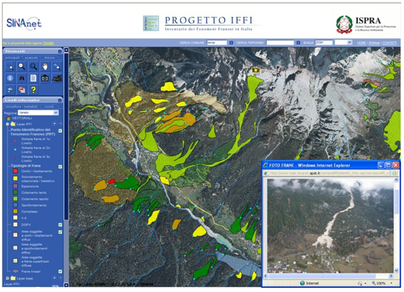
WebGIS application Cart@net-IFFI
The user can launch Cart@net-IFFI by selecting a region from the map of Italy on the left frame. Through a simple and clear navigation, the user can view the landslides of the IFFI Inventory together with other vector layers (urban areas - Corine Land Cover 2000, roads and railways, administrative boundaries, drainage system) and raster layers (digital terrain model, digital orthophoto TerraItaly it2000, Landsat satellite images and IGM topographic map). Moreover, it is possible to get information on the most important parameters of landslides, view documents, photos and videos.
Web Map Service
The WMS (Web Map Service) is an interoperability and interchange tool, which allows to share geographic datasets provided and managed from different sources via the Internet. The WMS (Web Map Service) of the IFFI Inventory has been developed according to the European Directive INSPIRE 2007/2/CE (Infrastructure for spatial information in Europe) and the Open GIS Consortium specifications. Through the WMS the user can access to geographic information independently from the GIS platform and get updated and official data, without unnecessary duplication. The user can access the WMS Service through a WMS viewer, as the one provided by the INSPIRE Geo-portal, or through a GIS Desktop (e.g. ArcGIS® ESRI).
The URL of IFFI WMS Map Service is the following:
Terms of use
The data published on the IFFI Project website can be viewed, queried and printed, while the download of files is not available.
The cartographic and alphanumeric information that can be consulted constitutes a significant basic knowledge framework on landslides in Italy.
However, it is necessary to integrate this information with specific studies and detailed field investigation.
ISPRA is not legally liable or responsible for accuracy, completeness, or usefulness of any information disclosed in this site.
For using the data and maps available on the IFFI Project website, the user has the obligation to specify the data source in any publication or other media as following: IFFI Project (Inventory of Landslide Phenomena in Italy) ISPRA - Department for the Geological Survey of Italy - Region / Self-Governing Provinces .... as well as to indicate the link to the original web page: http://www.progettoiffi.isprambiente.it.
The user is also required to:
a) notify to ISPRA any error or omission of information contained in the site, in order to contribute in improving the product;
b) avoid any action / activity that can damage the property rights and copyrights of ISPRA and other data providers


